
Whitewater Adventure and More in the Ocoee River Corridor
By Bob Butters

Rafters negotiate rapids on the Ocoee River. Photo © Bob Butters
Southeast Tennessee’s Ocoee River serves as an outdoor recreation gateway to the Blue Ridge Mountains. The 93-mile river begins in North Georgia, where it is known as the Toccoa River. The name changes to Ocoee once it enters Tennessee at Copperhill. 37 miles later it joins the Hiwassee River near Benton.
The Ocoee River is probably the Southeast’s most popular whitewater destination, hosting over 250,000 paddlers a year. A 2012 study determined that recreation on the Ocoee contributes $43 million annually to the economy within 60 miles of the river.
With Class III and Class IV rapids, the Ocoee features a 4.5-mile stretch of whitewater downstream from Ocoee Dam #2. Another attraction is a section upstream at the Ocoee Whitewater Center, where a half-mile section of the riverbed was redesigned for the 1996 Atlanta Olympics whitewater event.
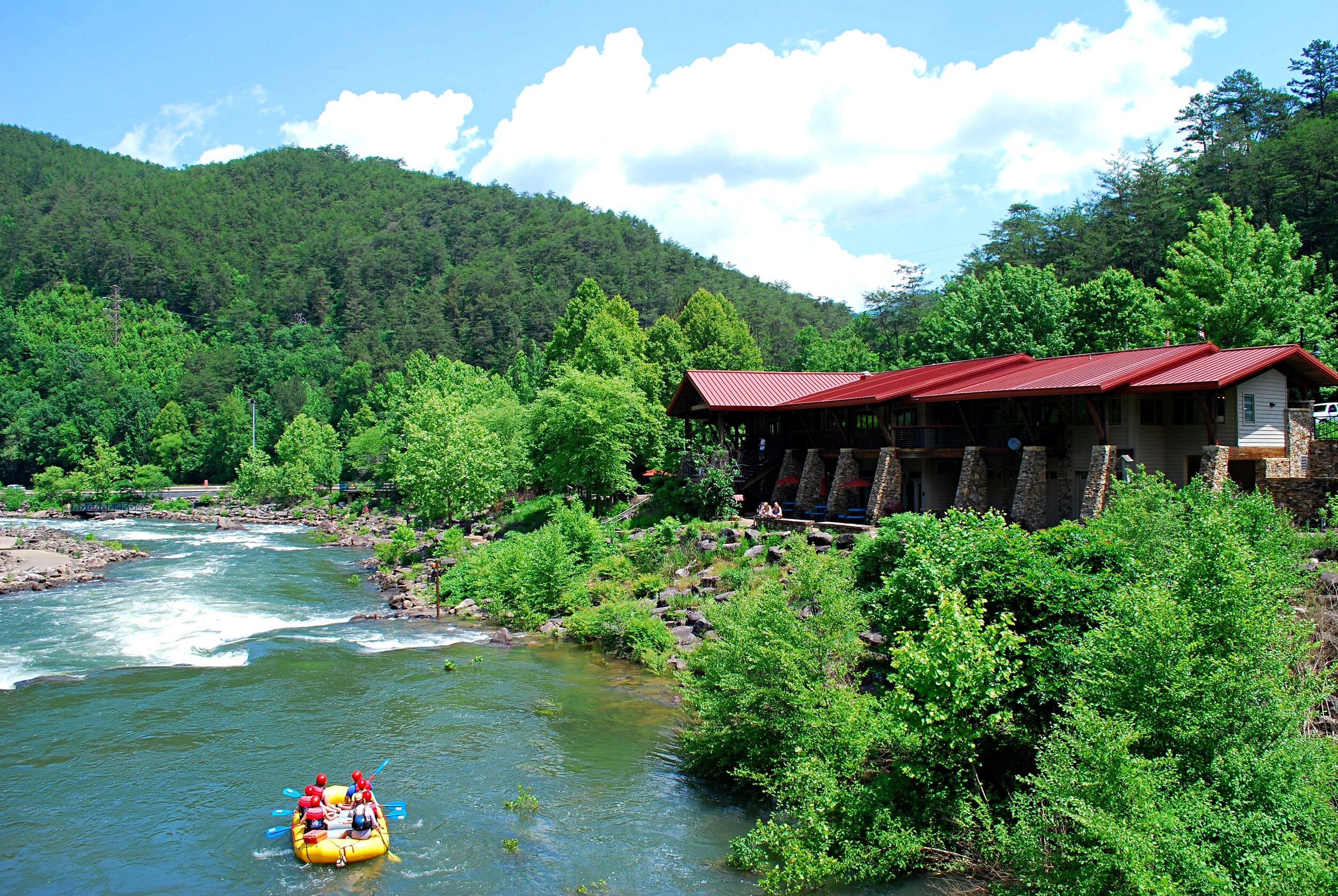
The Ocoee Whitewater Center. Photo © Bob Butters
The Ocoee River presents a unique example of collaboration among several government agencies. The flow of the river is physically regulated by the Tennessee Valley Authority for the dual purposes of hydroelectric power generation and river recreation. The land through which the majority of the river flows is part of the Cherokee National Forest, 650,000 acres of the Blue Ridge Mountains stretching along the entire eastern boundary of Tennessee, divided by Great Smoky Mountains National Park and managed by the U.S. Forest Service. Hunting and fishing within the national forest is primarily managed by the Tennessee Wildlife Resources Agency. The Hiwassee/Ocoee Scenic River State Park manages several river recreation access points, freeing up the Forest Service to focus on other tasks.
U.S. Highway 64, also designated as the Ocoee Scenic Byway, the first national forest byway in America, follows the shoreline of the Ocoee River for 15 miles from Parksville Lake’s Ocoee Dam #1 to the Whitewater Center and provides easy access to the river.

View of Parksville Lake from Chilhowee Mountain. Photo © Bob Butters
The scenic 1,900-acre Parksville Lake, also known as Lake Ocoee, has 47 miles of shoreline and offers a variety of recreational opportunities, including water skiing, jet skiing, pontoon boating, fishing, two public swimming areas, and more. Whitewater rafting trips, cabin rentals, motel lodging, marina services and more are offered by the Lake Ocoee Inn & Marina, located prominently on the lakeshore. Just upstream from the lake, a 2-mile section of the river before reaching rapids provides good flatwater paddling.
Parksville Lake’s Ocoee Dam #1, completed in 1911, is the oldest dam operated by TVA.
According to the Forest Service, whitewater recreation on the Ocoee primarily takes place from June to September, when releases from the Lake Blue Ridge Dam increases the flow of water on the river. Rafting and kayaking became popular on the Ocoee River after a landslide damaged the flume in 1976, resulting in water being diverted to the natural stream bed. By the time the flume was repaired, paddlers were reluctant to give up their fun on the river, so TVA began a schedule of releases allowing whitewater recreation to continue.
When water isn’t being released into the river for recreational use, much of it gets diverted for power generation. A large pipe carries water from Dam #3 to the Ocoee Powerhouse #3 just upstream from Dam #2. From Dam #2, the flume carries water along the mountainside above the river for nearly 5 miles to Powerhouse #2.
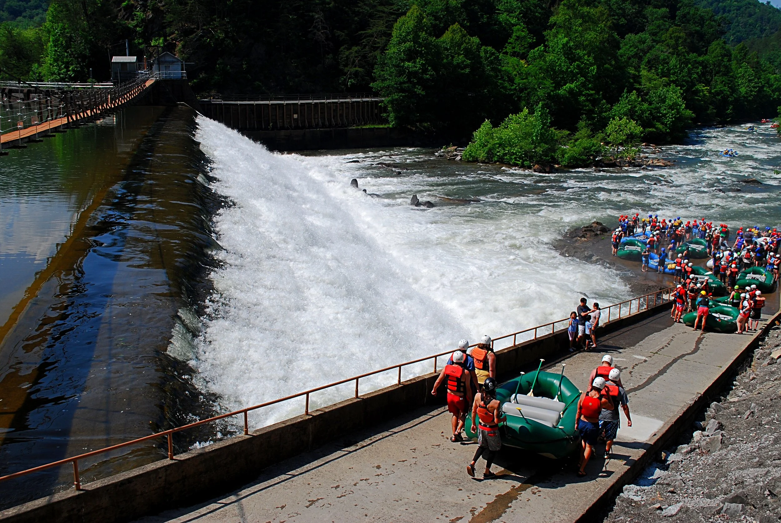
Rafters prepare to launch at Ocoee Dam #2. Photo © Bob Butters
In 2019, releases are scheduled on the upper section of the Ocoee for 34 days and on the middle section for 112 days. Click here for TVA’s recreation release schedules for all three Ocoee dams.
Built for the 1996 Olympic event, the Ocoee Whitewater Center is operated by the Forest Service and essentially serves as the visitor center for the Ocoee River corridor. The building, which includes a gift shop, is open April through October, but the grounds are accessible year-round. It serves as a lunch stop location for rafters who’ve put in just below Ocoee Dam #3 on their way to the takeout at Dam #2. A paved walkway and two foot bridges provide a short loop of about ¾-mile along the section of river that was redesigned for the Olympic event. Interestingly, due to the river’s restructuring, much of the walkway, along with some small wetland areas, is actually below the level of the water in the channel. The Whitewater Center is also the trailhead for over 30 miles of hiking and mountain bike trails known as the Tanasi Trail System.
Rising from the northern shores of Parksville Lake, Chilhowee Mountain is home to several scenic overlooks with great views of the lake and a popular mountain top recreation area. The Chilhowee Recreation Area features camping, picnicking, a 7-acre lake, and access to 25 miles of hiking and biking trails. The most popular hike here is the 3-mile round-trip trek to the 65-foot Benton Falls.
Whatever your preferred form of outdoor recreation, the Ocoee River corridor offers great opportunities to experience adventure in Southeast Tennessee’s Cherokee National Forest.
More Information
Find a list of companies offering guided rafting trips on the Ocoee, local outdoor stores, and businesses that offer kayak instruction or rent standup paddleboards, pontoon boats, fishing boats, canoes and more here.
View an interactive satellite map of the Ocoee River, showing access points and other features, here.
Click here to visit the Cherokee National Forest website.