
Hiking to the South Cumberlands’ Walls of Jericho
By Bob Butters

Hikers explore the amphitheater. Photo © Bob Butters
The natural feature known as the Walls of Jericho, located along the Alabama-Tennessee border south of Winchester, has become a popular hiking destination. As recently as the 1990s, it was part of 60,000 acres of land belonging to the family of Texas oil magnate Harry Lee Carter, who purchased the land in the 1940s. It required permission and involved a 10-mile hike/bushwhack/rock hop to visit.
Since then, the Nature Conservancy, Alabama Forever Wild Land Trust, and other organizations have worked to preserve over 21,000 acres around the Walls of Jericho as public land. In 2006, 8,900 acres on the Tennessee side became part of the Bear Hollow Mountain Wildlife Management Area and 750 acres became the Walls of Jericho State Natural Area. 12,500 acres on the Alabama side were added to the James D. Martin-Skyline Wildlife Management Area, which is a site on the North Alabama Birding Trail and home of Alabama’s only population of ruffed grouse. These lands contain several rare plant species and are part of the biologically rich Paint Rock River watershed.
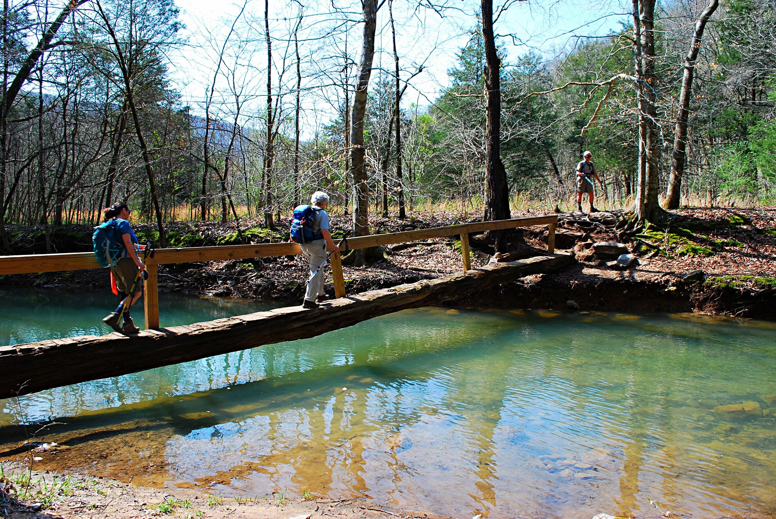
The log bridge over Turkey Creek. Photo © Bob Butters
So, What is this place?
The name Walls of Jericho refers to a narrow canyon, about a half-mile long, with 200-foot-high vertical limestone bluffs on each side. Cedar trees cling to the upper heights of the walls. The hike in culminates at a bowl-shaped area known as the amphitheater, where the waters of Turkey Creek emerge from the base of the bluff. Just past that, with a scramble over a short but tricky step-up in the canyon floor, you arrive at the end of any hiking in this direction, at a feature some call “the hole.” Here, water trickles, or sometimes pours, from upstream into a deep pit where it normally disappears into the ground.
According to legend, Davy Crockett explored the area in the late 1700s. The site was named by a preacher who performed baptisms there in the late 1800s.
Turkey Creek, which drains out of the Walls, joins Hurricane Creek, a tributary of the Paint Rock River. The 460-square-mile upper Paint Rock River watershed is known as one of the few large, intact, functional landscapes remaining in the Southeast and is of considerable biological importance. The Walls of Jericho State Natural Area is a designated stop on TWRA’s Tennessee Wildlife Viewing Trail. The region’s limestone geology is conducive to cave formation. Jackson County, Alabama, has the highest concentration of caves of any county in the United States.

During a time of unusually high water, a torrent emerges from a hole in the bluff to flow into Turkey Creek. Photo © Bob Butters
Hike Options
Today, there are two trailheads from which to hike to the Walls from Alabama Highway 79/Tennessee Highway 16, one on each side of the state line and about 2.25 miles apart. The hike from the Tennessee trailhead is about 3.7 miles one-way and is less steep than the Alabama trail. From the Alabama trailhead, it’s about 3 miles each way, but with a steeper trail. Either way involves an approximately 1,000-foot descent in and climb out.
Though the Alabama trail is steeper, it seems to be the preference of many, as it’s a shorter hike and the trail is in good condition. From the large gravel parking lot, which is also the trailhead for the 4.7-mile Bear Den Point Loop across the road, the trail is relatively level for a short distance before dropping over the bluff line. From here, the trail winds back and forth as it drops steadily down the mountainside toward Hurricane Creek. During times of plentiful rain there may be a number of gurgling streams plunging down the hillsides, some of them emerging directly from depressions in the ground.
The two trails converge on the banks of Hurricane Creek shortly before crossing on a footbridge consisting of a single large log, flattened on top with a handrail on one side. In spring, a short side trip upstream before crossing the creek will bring you to an area with a sizable population of Virginia bluebells (Mertensia virginica) in bloom.
After traversing a short distance through fairly level forest and crossing another log bridge over a normally dry point in Turkey Creek, which flows from the Walls of Jericho and soon joins Hurricane Creek, you’ll come to a small cemetery and primitive campground.
Here, you’ll turn northwest and begin to enter the increasingly deep and narrow Walls of Jericho canyon. Be alert for the intersection with the South Rim Trail. Taking it to the left will take you up along the top of the canyon, while staying to the right will take you to your destination, the large natural limestone amphitheater and waterfall. This final half-mile section of the trail, while following an overall consistent elevation, is probably the most rugged part of the hike, as it basically clings to the steep canyon side along Turkey Creek and can be a bit muddy and rocky.
Along the way, the trail crosses the line into Tennessee. The only clue is a small sign about Alabama hunting regulations in the area you just came from. Just before reaching the amphitheater area you’ll have to walk the creek bed. Usually, you’ll manage to keep your feet dry here, but with higher water, it could be challenging.
Despite its moderate length, it’s recommended to allow six hours for this hike. For most people, the climb out will take awhile, and you’ll want to allow adequate time to explore the canyon, where you’ll probably want to eat lunch as well.
While summer is a popular season for this hike due to the potential for stream wading, an advantage of doing it during winter is more extensive visibility allowed by the lack of foliage, including views of mountainsides on the opposite side of the valley, the bluffs at the beginning of the Walls, and a stretch of Hurricane Creek.
Though it’s only a 6-mile hike, you’ll feel like you’ve done more. Because of the climb and the fact that you’ll probably want to spend some extra time in the amphitheater area, it’s recommended that you allow more time than you might normally need for a 6-mile hike.

With a heavier than usual flow, the falls marks the end of the Walls of Jericho trail. Photo © Bob Butters
GETTING THERE:
The Walls of Jericho trailhead is about a 1.5-hour drive from downtown Chattanooga.
From Chattanooga, follow I-24 W to South Pittsburg and get on US-72 W. Turn right onto County Road 33 in Hollywood, AL, and follow for 23 miles to the trailhead on the left. The Tennessee trailhead is a couple miles up the road.
GPS coordinates for the TN trailhead: 35.000075,-86.055998
AL trailhead: 34.976575,-86.080473
Note: There are also two trailheads for equestrian trails. The only thing to differentiate them from the hiking trails are signs with a horse symbol versus signs with a hiker symbol.
Click here for a trail map.